


Fort Mahler

Akis
User
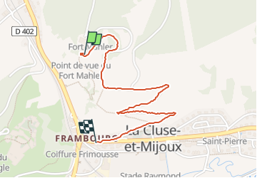

Length
1.8 km

Max alt
1017 m

Uphill gradient
1 m
Km-Effort
2.3 km

Min alt
863 m

Downhill gradient
147 m
Boucle
No
Creation date :
2025-05-30 14:15:34.0
Updated on :
2025-06-08 06:44:04.786

FREE GPS app for hiking
 SityTrail
IGN / Geographical institutes
SityTrail Plus
The world is yours!
About
Trail of 1.8 km to be discovered at Bourgogne-Franche-Comté, Doubs, La Cluse-et-Mijoux. This trail is proposed by Akis.
Positioning
Country:
France
Region :
Bourgogne-Franche-Comté
Department/Province :
Doubs
Municipality :
La Cluse-et-Mijoux
Location:
Unknown
Start:(Dec)
Start:(UTM)
300191 ; 5194689 (32T) N.
Comments